S-100 is the new International Hydrographic Organisation (IHO) framework for sharing marine data in digital navigation systems. Tidetech turns that framework into practical products — starting with:
S-104 water levels
S-111 surface currents
Supported by S-102 high resolution bathymetry
This means ports, pilots and vessel operators can see how water levels and currents are changing as an interoperable layer in their navigation system.
S-100 is the IHO's data standard for the next generation of electronic navigation.
In practice, that means:
A common structure for many data types (depths, water levels, currents and more)
Data that is interoperable across S-100 -ready ECDIS, navigation, vessel traffic management and other systems
A pathway for richer, dynamic layers on top of traditional charts
S-100 is less about the standard itself and more about what it enables — water levels, surface currents and other metocean layers that plug into systems mariners already use.
S-104 is the S-100 product specification for water level information used in navigation.
It answers a simple but critical question — how high is the sea surface relative to chart datum along my route, right now and over the next few hours?
With S-104 water levels you can:
Refine under keel clearance (UKC) calculations in shallow or constrained waters
Plan more precise tidal windows for deep draught vessels
Improve safety margins in bar crossings, river entrances and port approaches
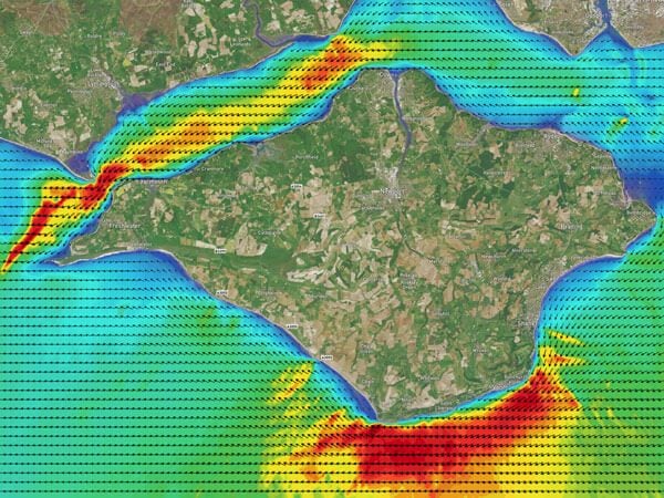
S-111 is the S-100 specification for surface currents — speed and direction at or near the surface.
For shipping, ports and pilots, this helps with:
Pilotage and manoeuvring — understanding cross set and drift in turns, channels and berths
Transit planning — using favourable currents, avoiding adverse ones
Risk management — identifying areas where eddies and shear zones may affect track keeping
Tidetech’s S-111-ready models provide gridded current fields that can be visualised directly in compatible navigation and decision support systems, alongside chart and AIS layers.
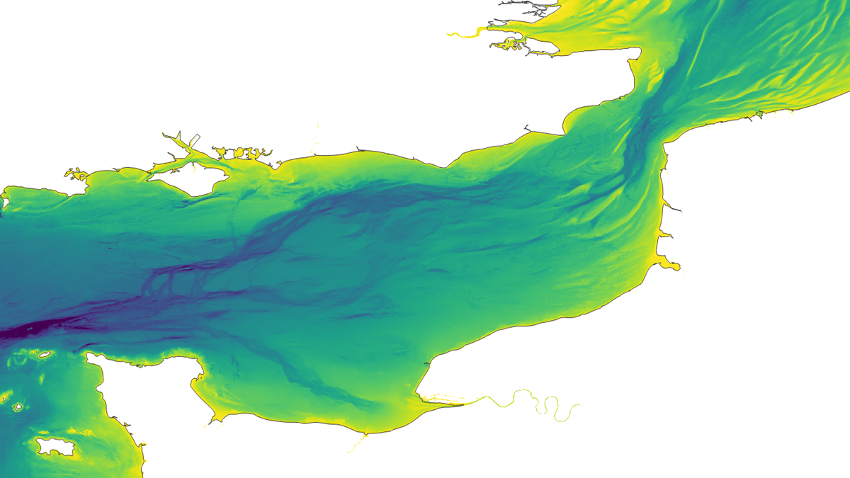
You cannot safely interpret dynamic water levels and currents without a good picture of the seabed.
S-102 is the S-100 product specification for high resolution bathymetric surfaces. It effectively replaces a single chart sounding with a detailed depth grid.
For Tidetech, S-102-quality bathymetry is the foundation that allows us to:
Resolve channels, shoals, banks and harbour basins accurately
Simulate how tides and currents accelerate, slow or diverge over these features
Support more reliable S-104 and S-111 outputs, particularly in shallow, coastal and port environments where accurate depth relative to chart datum is critical
In short, S-102 underpins the quality and usefulness of S-104 and S-111. However, Tidetech does not supply S-102 as an interoperable product — these are available from hydrographic offices or certified suppliers.
Tidetech is rolling out S-104 and S-111 coverage in priority regions for shipping and pilotage.
Current model coverage includes:
Irish Sea
The Solent and English Channel
Australia — north east coast (Gladstone to Cairns, and Moreton Bay)
Torres Strait
Port Botany (Sydney)
Port Melbourne
Each model is configured for local bathymetry and tidal regimes, with S-104- and S-111-ready outputs for use in S-100 workflows.
Tidetech’s S-100-ready products are designed to:
Integrate with ECDIS and navigation software that support S-100 or equivalent data feeds
Work through pilotage tools and portable pilot units (PPUs) in S-100 or vendor specific formats
Feed port call and decision support systems that combine bathymetry, UKC policy and metocean inputs
The adoption of these new information layers offers the opportunities for fuel savings, reduced emissions, improved just-in-time logistics, virtual arrival, scheduling, safety, and enhanced passenger comfort.
We handle the model configuration, validation and packaging. You decide where and how the data appears for your users.
If you are exploring S-100 for ports, pilotage or other maritime applications:
Talk to an ocean data specialist — to discuss S-104 and S-111 options for your region
Learn more about the S-100 standard and hydrographic office roll-out below.