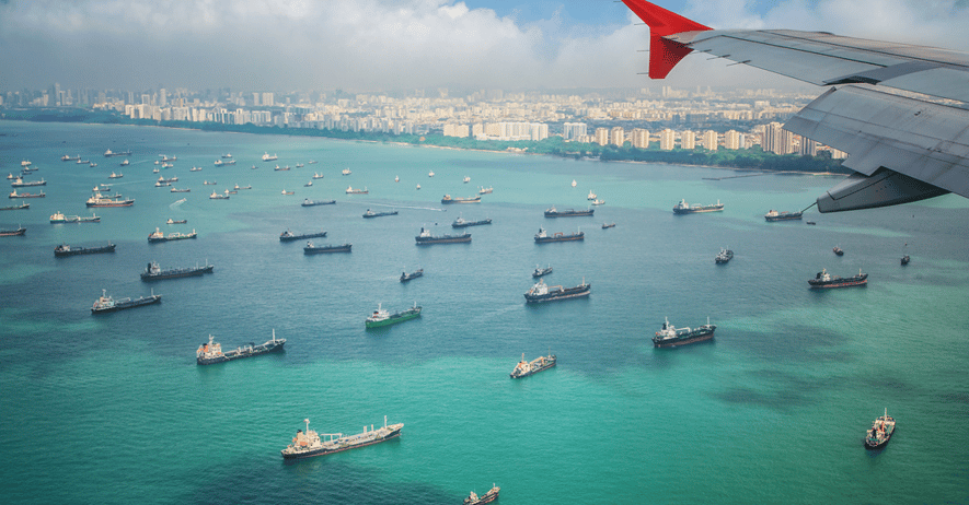
At 16km wide, and stretching 105km long between the Strait of Malacca and the Karimata Strait, the Singapore Strait is a crucial gateway between Asia and Europe. Due to the high number of ships transiting the area, the Singapore Strait can become incredibly congested and requires a tight traffic management system to ensure that vessels are coming into port at the right time, every time.
The tides flowing in the Strait are powerful, and complexities within the currents can affect vessel transit times. In this article, we examine these complexities to understand what makes up the turbulent and changing nature of the Singapore Strait.
Why are the Currents in the Singapore Strait so Complex?
One of the Singapore Strait's fundamental complexities arises from its location, as the link between two oceans, the Indian Ocean to the West and the Pacific Ocean to the East. It is strongly affected by the different dynamics of these ocean basins which interact with the locally generated currents in the Strait, resulting in complex dynamics between competing influences.
Tidal Influences
The Singapore Strait is subject to the tidal regimes of these two connected bodies of water. On its Eastern side it connects to the South China Sea, which experiences predominantly diurnal (once daily) tides associated with the Pacific Ocean.
The Western side connects to the Indian Ocean which has predominantly semidiurnal (twice daily) tides.
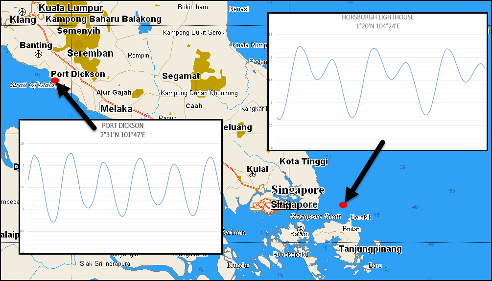
Fig 1. Comparison of semi-diurnal tidal curve at Port Dickson at the Western side of Singapore Strait with the mainly diurnal tidal curve at Horsbugh light at the Eastern end.
Consequently, tides within the Singapore Strait are asymmetric with different patterns at Springs vs Neaps.
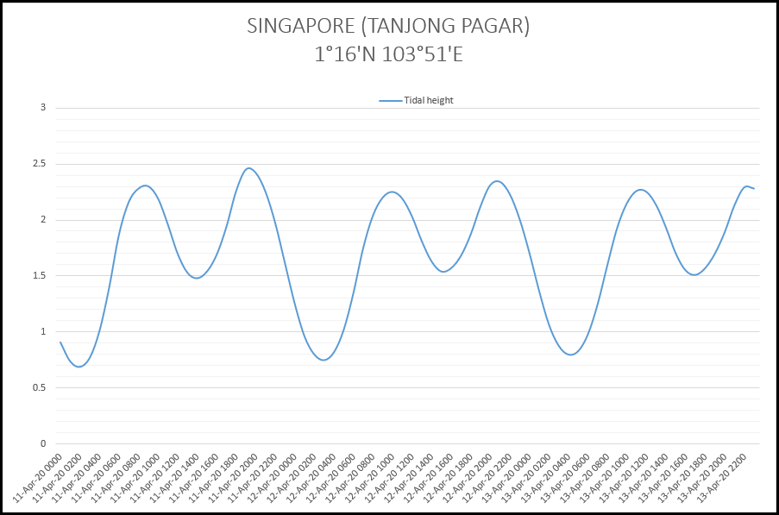
Fig 2. Tidal curve for the Port of Singapore for 72hrs at Neap Tides, showing a mixed regime of diurnal and semi-diurnal influences.
Monsoonal Influences
Seasonal monsoons result in temporary differences in sea level height between each side of the Straits. These height differences are caused by persistent monsoon winds, which blow steadily from one direction for months at a time. For example, in the North-East monsoon season between November and March, Northeasterly winds blow over the South China Sea, causing water to pile up at its Southern end.
This creates a hydrodynamic pressure gradient between the Strait's Eastern and Western sides, resulting in a steady flow of water from East to West of between 1 and 1.5 knots.
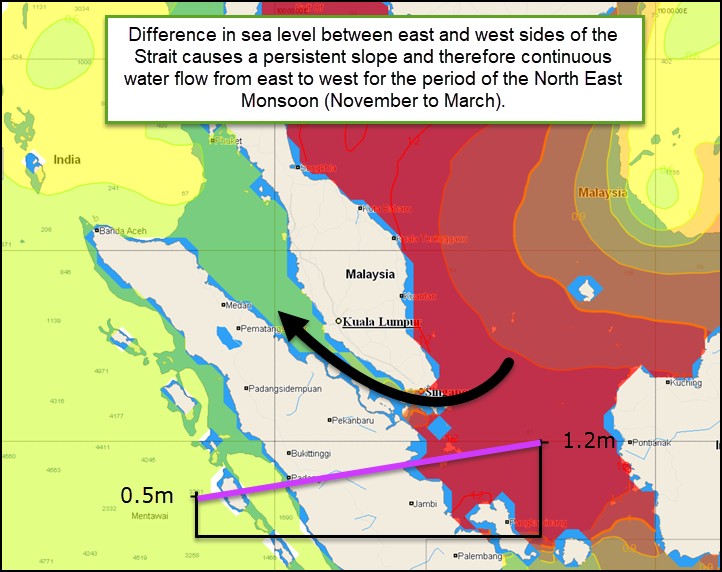
Fig 3. Differences in monsoonal sea level height between the Eastern and Western sides of Singapore Straits
When the South-West monsoon takes effect between June and September, the gradient reverses resulting in a continual Easterly flow of up to 0.5 knots. Between these monsoon periods, these gradient effects may be completely absent.
Local Interactions
Interactions between the tidal and monsoonal currents add further to the complexity of the regime.
For example, in the North-East monsoon season a continuous West-flowing monsoonal current increases the rate of the existing West flowing tidal current, and decreases the rate of East flowing tidal current:
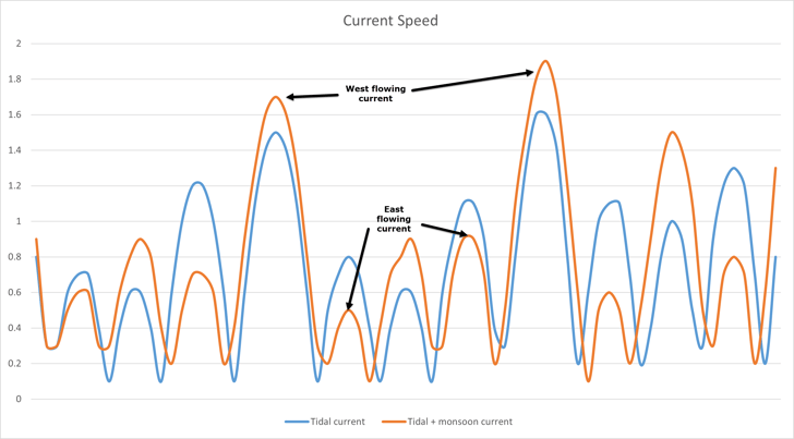 Fig 4. Differences between the speed (kts) of tidal and monsoon influenced currents in the Singapore Straits over a three day period at Neap tides
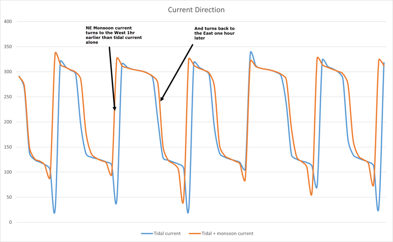
Fig 4. Differences between the direction (deg) of tidal and monsoon influenced currents in the Singapore Straits over a three day period at Neap tides
Using Singapore Strait Tides to Your Advantage
For Mariners transiting the Straits, none of this is straightforward to deal with, and the complexities of navigating the tides in this region can significantly impact a ship's operational efficiency.
Tidetech's hydrodynamic model of the region provides a precise forecast of current speed and direction in great detail, which, when incorporated into vessel navigation software, allows ship owners and operators to focus on achieving just-in-time arrivals and accurate scheduling.
Sign up below for a free trial.


