Shipowners run the risk of channelling funds into voyage optimisation solutions that don't target one of the most significant factors impacting their vessel performance.
Voyage intelligence and insight specialist StratumFive reports that weather accounts for a massive 80% of the impact on vessel performance.
So why aren't more voyage analysts considering this and utilising tools at their disposal to optimise vessel efficiency?
Hindcast weather data is one such tool available to voyage analysts and ship owners that can provide them with the necessary information to tease out variables that have the potential to affect future vessel performance.
What is Hindcast Data?
Hindcast is the correct term for validated historical weather and ocean data which is somewhat different to the original forecast because it has been 're-analysed'. Before each forecast model run millions of observations are ingested in the 'setup' phase to provide the 'best' possible conditions for the start of the forecast. These observations are obtained from the GTS (Global Telecommunication System) run by the WMO (World Meteorological Organisation). However, the effect of these observations on the forecast rapidly reduces the further into the future you go. Hindcast data includes extra observational data that was time-delayed and therefore not available to the original forecast run. This means that hindcast data is more accurate than archived forecast data.
Tidetech provides analysed hindcast data in two different ways:
- Actual wind, wave and current data that occured at discrete lan / lon pairs at specific dates and times
- Climatological data - mean values for weather, waves and currents for a defined period at specific locations - as in the image below.
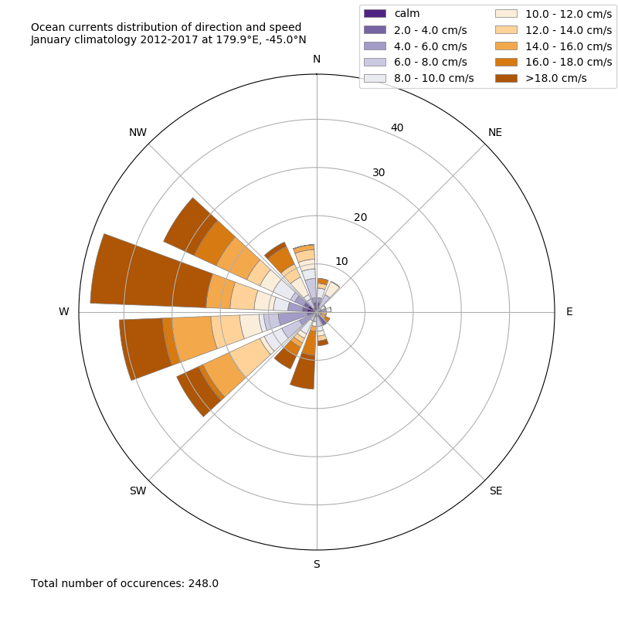
Tidetech Ocean current statistics for January for 179.9deg E and 45 deg S
How to use Hindcast Weather Data to achieve optimal vessel performance
Reflecting on the past helps us make decisions in the best way possible in the future.
Looking back at past vessel performance can help when planning for future voyages and provide an understanding of why certain routes are taking longer.
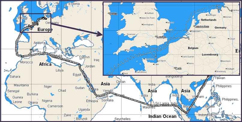
Typically, GPS tracking data from past vessel voyages is used and wind, wave and current data are obtained for each point on the voyage. The image below shows tracking data from a large container vessel in a multi-stop voyage from Hamburg to Shanghai. This data was sent to Tidetech's API and accurate weather, wave and current data was returned for every single point from the voyage, for each of the dates and times concerned.
Understanding the impact of environmental data on your fleet helps you analyse and benchmark performance, enabling you to reduce your fuel consumption, lower your emissions, and thereby slash your costs – while also creating a safer voyage for crew and passengers. Anyone operating in the maritime space could potentially benefit from accessing this data.
Why is Hindcast Weather Data better than other data sets?
The hindcast weather and ocean data we use at Tidetech is derived from scientific institutions (e.g. European Centre for Medium Range Weather Forecasting, ECMWF) and from our own models . Compared to forecast data these data are a continuous blend of observations and model which are carefully assembled to provide as near as possible the actual conditions occurring at any particular time and place.
Hindcast weather data allows shipping companies or software providers to produce a 'digital twin' – enabling them to create a digital vessel that will predict operations during certain conditions, for example assessing how the vessel will perform in future wave conditions based on how it behaved in the past.
Tidetech's offering is unique - in addition to our forecast products we provide global hindcast environmental data for weather, waves and currents dating back to 2014 and high resolution regional wave and current data back 12 months.
Sign up below for a free trial of our API and start optimising your fleet's performance.