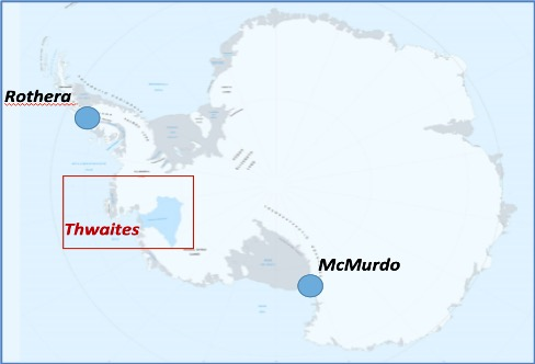
After the disappointing outcomes of the COP26 meeting in November to address the IPCC 6th Assessment requirements over the coming decades, a potentially more immediate existential threat to global sea level rise was discussed in a press conference at the American Geophysical Union Fall Meeting in December. Titled “The threat from Thwaites: The retreat of Antarctica’s riskiest glacier”, the hour-long presentation discussed the mid-term status of the International Thwaites Glacier Collaboration (ITGC) 5-year study into the stability, or rather instability, of the Thwaites Glacier or ‘Doomsday Glacier’ in popular terminology.
Stressing the importance to sea level rise of the Thwaites Glacier and its role in holding back a significant portion of the West Antarctic Ice Sheet, post-doctoral research associate Ella Gilbert summarised key facts from the ITGC conference in The Conversation. Here are the key facts reported and why they’re important:
1) Thwaites Glacier is retreating rapidly as a warming ocean slowly erases its ice from below, leading to faster flow, more fracturing, and a threat of collapse.
2) The glacier has doubled its outflow speed within the last 30 years, it is already contributing 4% of sea level rise, and the glacier in its entirety holds enough water to raise sea level by over two feet (0.65m).
3) The fracturing of the Thwaites Eastern Ice Sheet, the floating ‘plug’ holding back the glacier, has significantly increased in the past 5 years, and could lead to break up within 5 years.
4) If the glacier draws the surrounding glaciers of the West Antarctica ice sheet with it, it could lead to even more sea-level rise, up to 10 feet (3m).
More details are provided on the ITGC fact sheet.
The fracturing (rifting) is the most disturbing development reported by the ITGC. As glaciologist Erin Pettit points out, “The rifts are propagating into the central part of the ice shelf at rates as high as 2km per year.”
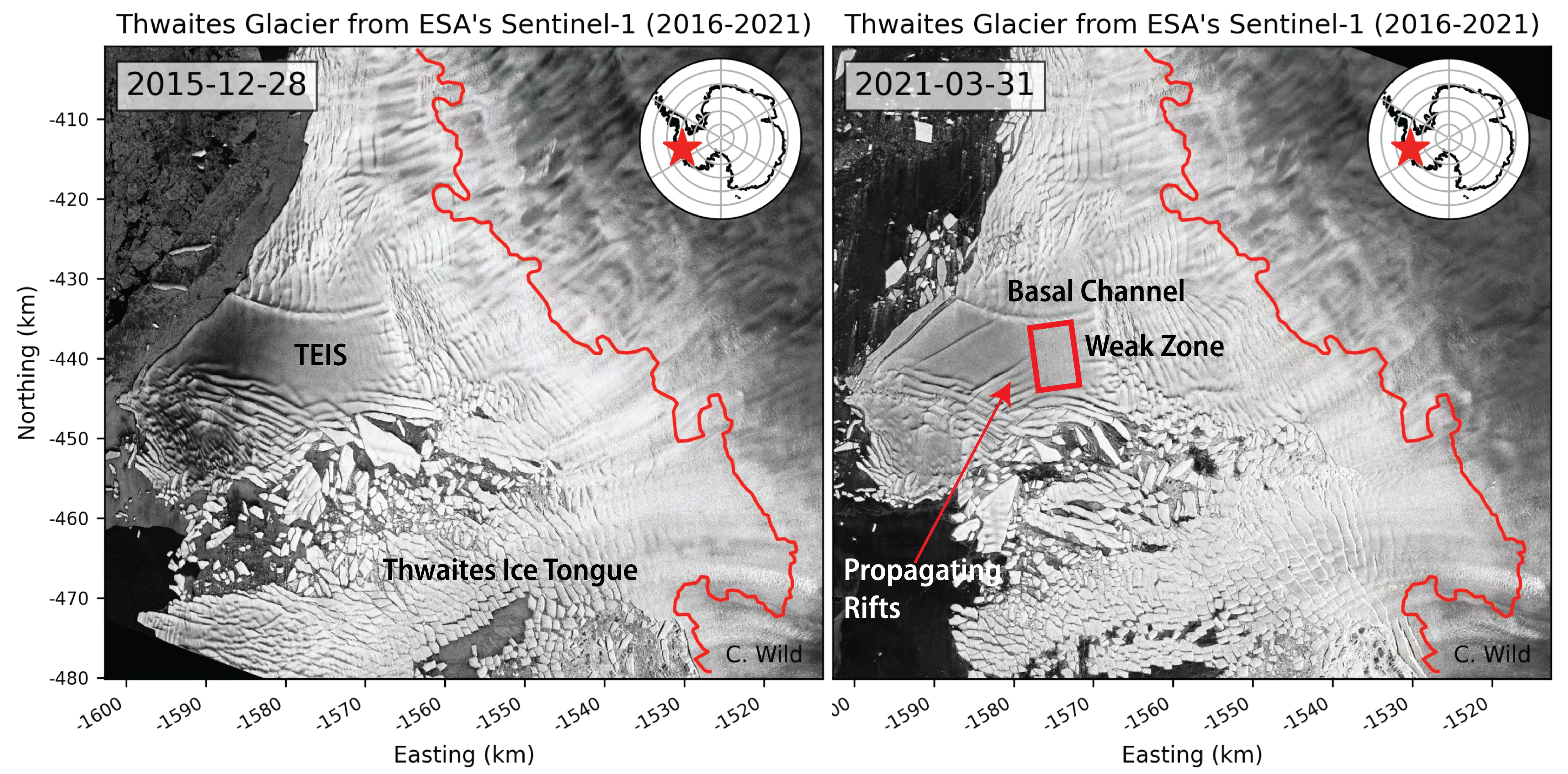
She further adds, “Over the last several years, satellite radar imagery shows many new fractures opening up. Similar to a growing crack in the windshield of a car, a slowly growing crack means the windshield is weak and a small bump to the car might cause the windshield to suddenly break apart into hundreds of panes of glass”.
There are three drivers accelerating the break-up of the Thwaites Glacier Eastern Ice Shelf, as illustrated in this snapshot from the press conference:
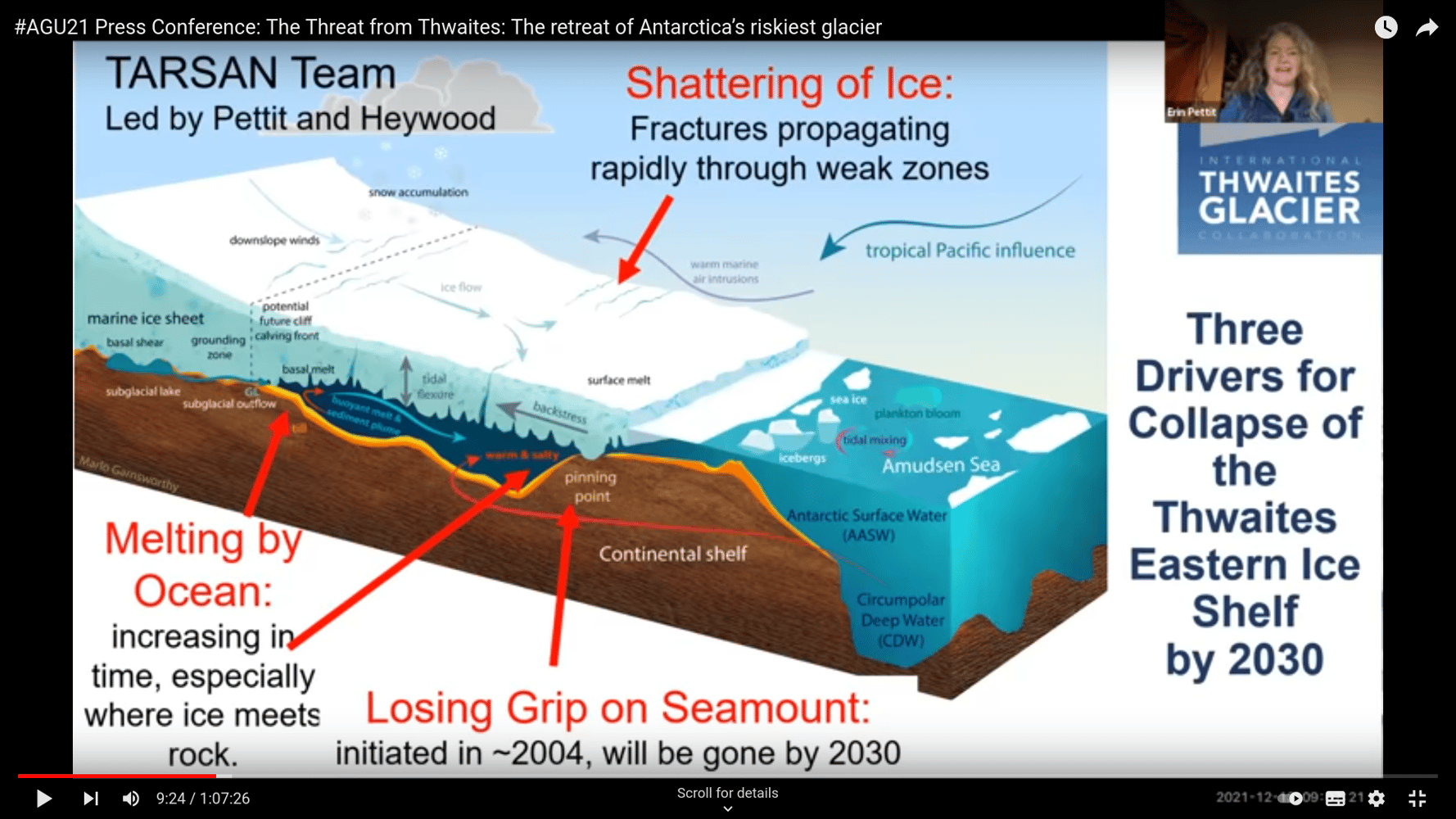
1) Melting of the ice by climate-driven warm ocean water from underneath, reaching further into the glacier
2) Losing the grip on the seamount at the leading edge of the ice flow, predicted to happen by 2030
3) Shattering of the ice sheet by fractures propagating rapidly through weak zones, possible within 5 years, and likely to bypass the seamount grip.
These timescales should be sufficient to raise the urgency of climate action and to recognise that climate change is unlikely to be a slow process and that tipping points, resulting in rapid change, are very likely.
Getting back to sea level rise, as Ella points out “A sea level rise of several metres would inundate many of the world’s major cities – including Shanghai, New York, Miami, Tokyo and Mumbai. It would also cover huge swathes of land in coastal regions and largely swallow up low-lying island nations like Kiribati, Tuvalu and the Maldives”. It is still a highly complex problem predicting when this may happen and involves timescales beyond the end of this century.
Sea level change through to 2050 is largely locked in, as Robert Kopp explained in another Conversation article discussing the IPPC Climate Change Report. Regardless of how quickly nations are able to lower emissions, the world is likely looking at about 0.15 to 0.3m of global average sea level rise. Beyond that, depending on the differing IPCC scenarios, sea level rise reaching 0.5-0.7m is expected by 2100, unless the extreme scenario is considered which includes ice sheet instability processes leading to sea level rise approaching 2m; this is considered ‘low likelihood’. However, as noted above, should Thwaites glacier disintegrate and enter the ocean in this timescale, this alone will contribute more than 0.65m.
Here at Tidetech we are strongly engaged, through analysis of observations and modelling scenarios, with understanding the impacts of these changes on the ocean as many of the products we offer, like sea level forecasts, are potentially sensitive to climate change and changing sea levels especially in coastal areas. Using satellite LiDAR data, Hooijer and Vernimmen show that by 2100, significant changes to coastlines in coastal seas are likely in the tropics and particularly South East Asia. The loss of land to the ocean, likely to result in large scale human migration, is also likely to lead to additional coastal inundation, with return periods of major storm flooding reducing. Around the globe we are seeing communities responding to climate impacts: building code changes are being made in low lying US States like Florida; the small Welsh town of Fairbourne has been dubbed the first UK town to be left to the oceans; and here in Australia we see some coastal residential homes struggle to attain insurance as the risk is already too high.
As recent technology advances enable new discoveries about Antarctica it is likely that further concerns about the pace of rising sea levels will increase, for example the discovery of a giant canyon beneath Vanderford glacier could accelerate its melting from beneath.
As Tom Mortlock points out (when referring to Thwaites glacier): “It demonstrates the high uncertainty in sea level rise projections over the coming century”. Are the appropriate risk assessments being made?